Research
April Fools Tidal Wave
Downtown Hilo
Island of Hawaii
DC Class X - Natural Condition, Tidal Wave
![]()
 |
Many locals did not heed the tidal warnings on |
Tidal waves, or tsunami (pronounced su-naw-me), are large rapidly moving waves triggered by a major disturbance, such as an earthquake, volcanic eruption, or submarine landslide. In deep waters, the waves are only a few feet high, travel at 600 mph and cannot be detected by a ship at sea or be seen by aircraft. On April 1, 1946, a tidal wave, which originated in the Aleutian Islands, struck Hawaii and killed over 170 people, mostly in Laupahoehoe and Hilo, where the wave heights averaged 30 feet. The maximum wave height was 55 feet at Pololu Valley on the northern tip of the island. Much of downtown Hilo was demolished, and a schoolyard clock, frozen at 1:05, stands as a memorial, marking the exact time of the destruction. Another tidal wave hit Hilo on May 23, 1960, but due to more advanced warning systems, only six people were killed.
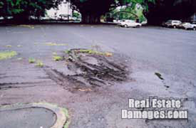
As mentioned, much of the downtown areas of Hilo were completely destroyed. Much of the eastern areas of downtown Hilo have never been rebuilt. Many empty blocks of old streets, gutters, and sidewalks still exist. Lili'uokalani Gardens, a major tourist attraction, replaces an area that was once improved with various structures. After the 1946 tidal wave, the debris was bulldozed into large piles, soaked with kerosene, and burned. Over the years, the buried, burnt debris has decomposed and has caused considerable soil subsidence problems throughout the area. For example, many parking lots have large open holes and depressions. A civil defense warning system and evacuation routes are located throughout the area, and the threat of another tidal wave still exists today. In addition to the continuing threat of tidal waves, Hilo is also in a Class 2 Volcano Zone (1 is most dangerous and 9 is least). Recent lava flows came within four miles of the city.
 |
Water Level on Restaurant Window |
 |
Sink Hole in Parking Lot |
<<Return to Research Page
